Aero Ops 360
One Tool. Complete Airfield Visibility.
Every movement. Every aircraft. Every minute—logged, visualized, and reported in realtime.
Why It Matters
Airports and FBOs need more than radar—they need records. Aero Ops 360 delivers the data that supports your funding, staffing, compliance, and planning decisions, without spreadsheets or guesswork.
Know When, Who, and How Often
Track based vs. transient activity. Identify your busiest hours. See which airlines and operators are using the field and how with live ADS-B tracking.
Master Plan-Ready Data
Generate operations summaries by aircraft type, weight class, and design group—perfect for FAA grant justification and pavement planning.
Regulation Simplified
Easily retrieve arrival/departure logs, aircraft counts, and weather overlays to support environmental reviews, noise complaints, and FAA audits.
Always Available, No IT
Browser-based access means you get instant insights from any device—without installing software or managing servers.
Operational Awareness
From tower to tarmac, Aero Ops 360 gives operations teams the live tools they need to keep aircraft, personnel, and information moving smoothly. Everything updates in real time, so your decisions are always based on the latest field activity—not a delayed report.
Live Tracking with Context
See every aircraft currently in the air or on the ground, with visual labels, tail numbers, and movement trails. Zoom in on your field or pan across your airspace—tracking is networked, responsive, and filterable.
Arrival & Departure Visibility
Scroll through your current, upcoming, or historical ops. Search by tail number, airline, or time. Link flights to NOTAMs, runway use, or staffing logs instantly.
Replay, Review, and Export
Replay any time range like a video—with full aircraft movement, timing, and playback controls. Export flight activity videos or static images for internal reports or external reviews.

Aircraft on Field, Mapped and Counted
Instantly identify aircraft that have landed but not yet departed. See how long each has been grounded, and whether they’re based or transient.
Ops Dashboards That Actually Matter
View hourly activity curves, runway distribution, aircraft types, top operators, and more—presented clearly, filterable by date range, and exportable for quick reports.
Ops-Ready Weather Tools
Overlay real-time and historical wind, temperature, dew point, and barometric pressure data on your traffic timelines. Identify patterns that impact runway selection, delay risk, or noise concerns.
Planning and Forcasting
Back Every Grant and Expansion Plan with Real Data
When it’s time to justify a new hangar, extend a taxiway, or defend your Master Plan, Aero Ops 360 gives you what FAA reviewers actually want to see: clean, specific, and defensible data—down to the design group, engine type, or approach category.Trend Reports
Review monthly or annual summaries of all aircraft activity. Break it down by engine type, weight class, or airline operator. Flag seasonal patterns, repeat users, and aircraft that shape your field’s long-term needs.
Based vs. Transient
Whether you're tracking fee-eligible traffic or qualifying for grants, accurately tagging and separating based vs. itinerant activity is essential. Our tools help you do both—and display the results in exportable form.
Design Group Data
FAA grants depend on understanding what your field actually supports. Aero Ops 360 calculates and visualizes aircraft design group usage, showing which runways are over- or underused based on aircraft geometry, weight, and approach category.
Runway & Tarmac Zone Tracking
Geofenced overlays show which aircraft land where—perfect for pavement condition studies or construction detour planning. Know exactly how your surfaces are being used, by whom, and how often.
Master Plan Support
Generate export-ready graphs and reports to include directly in FAA documentation or board presentations. Planning dashboards deliver the detail while keeping it readable.

Aero Ops 360 Subscription - $1800/yr
We provide the equipment. We maintain it. You just log in and use it...
Full access with Aero Ops 360, including:
-
Live tracking and historical replay
-
Full reporting and dashboards
-
Administrative tools and user controls
-
Included hardware and support—no extra fees, no surprises
Administrative Control
Admin Tools That Work Across Departments with Aero Ops 360
Behind every clean report and smooth operation is an admin team making sure records stay accurate and accessible. Aero Ops 360 includes a full suite of administrative tools designed to streamline oversight, reduce errors, and support collaboration across operations, planning, and finance.
NOTAMs, Centralized and Searchable
View FAA and local notices all in one place—filter by date, origin, or status. No more jumping between platforms or missed updates.
Noise Complaint Handling with Flight Path Review
Log complaints, review timestamps, and instantly pull up the corresponding aircraft path. Easily confirm or dismiss based on real data.
Based Aircraft & Fleet Management
Add, edit, and tag aircraft by tail number, category, or type. Organize them by status—based, transient, tiedown, training—and apply grouping for billing or exemption tracking.
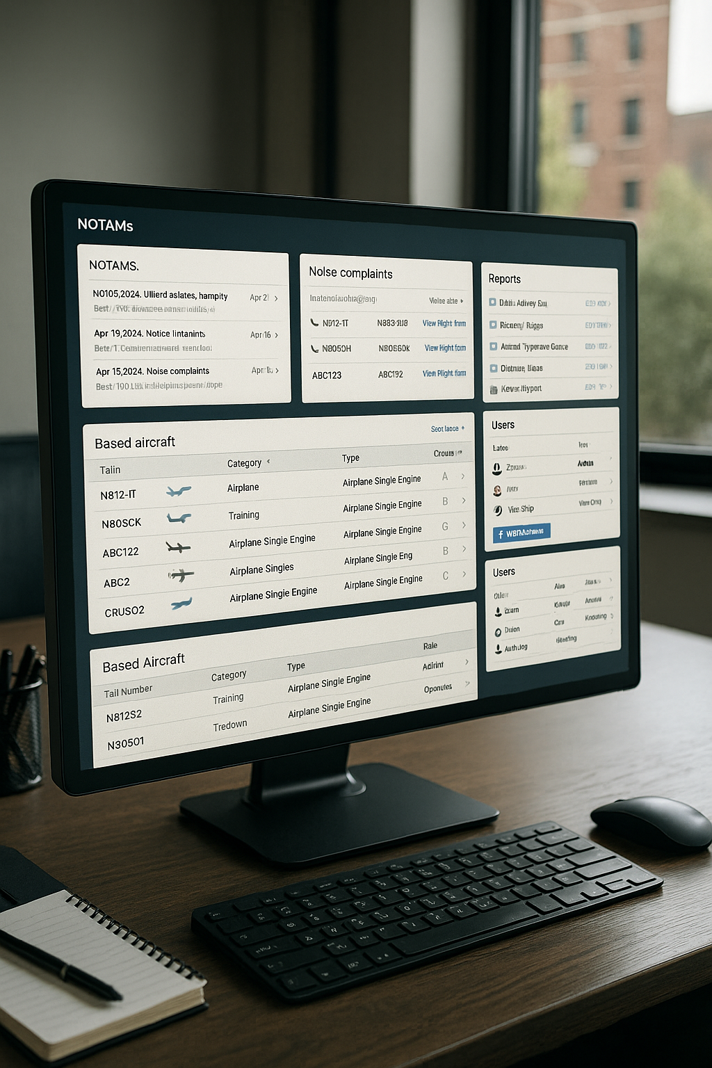
Export What You Need, How You Need It
Generate reports in PDF or CSV formats—by user, date, aircraft type, or operational zone. Perfect for invoicing, grant backup, or internal auditing.
Custom Grouping and FAA Data Integration
Use real FAA codes to standardize your records. Assign aircraft to design groups, weight classes, or approach categories to match regulatory planning needs.
Built-In Invoicing Tools
Define date ranges, apply fee logic, and generate billing statements in minutes.
Integrates with Aero Reserve for full scheduling + billing sync.
Equipment and Infrastructure
Your Field-Level Gateway to Nationwide Air Traffic
When you install Aero Ops 360, you’re not buying hardware—you’re joining a fully managed, professionally maintained network. Our ground-based stations are built for low-altitude visibility, giving you a view of aircraft that satellites miss—especially in the first 1,500 feet where most local activity happens.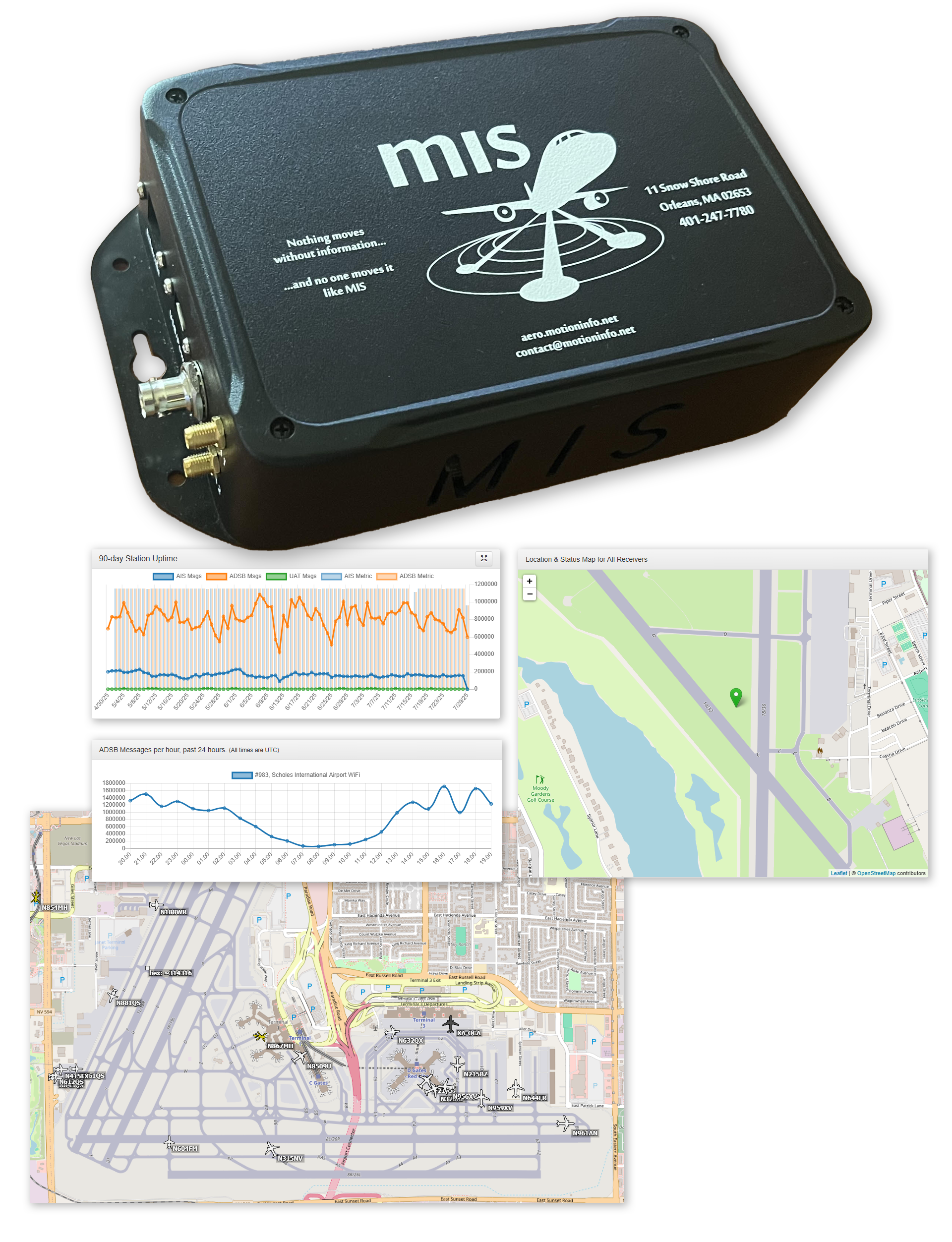
Purpose-Built, Always Supported
We provide and install all required equipment. You don’t need to purchase or maintain a thing. Each station includes our compact AIS/ADS-B/UAT receiver unit, tested for 24/7 reliability in your environment. If there’s ever an issue, we repair or replace it at no charge—no support plan, no hidden fees.
Built for Low-Altitude Coverage
Our systems track aircraft as they take off, land, or circle nearby—areas where satellite systems lose visibility. If terrain, trees, or structures block part of your airspace, we’ll solve it with additional hardware placements at no extra cost.
You Provide Power & Internet*
All we need from your team is a stable connection and an outlet.
Part of a Nationwide Network
Once you're online, your station becomes part of the 700+ unit MotionInfo network. You get access to traffic and visibility data from all our locations—not just your own—so you can track inbound aircraft long before they appear on radar.
Included UAT Support
In addition to ADS-B, all units support UAT (Universal Access Transceiver) channels—used by many general aviation aircraft and vehicles for low-altitude broadcast. This expands your visibility to smaller aircraft and operations that aren’t always captured by traditional tracking tools.
*Don’t have the necessary setup? We offer optional connectivity and solar solutions.
See Aero Ops 360 in Action
Request a personalized demo of Aero Ops 360 and we’ll walk you through exactly how it can support your team—from real-time tracking to Master Plan exports.
What you’ll get:
-
Live walkthrough of tracking, dashboards, and reports
-
Answers to your site-specific questions (airport size, aircraft mix, etc.)
-
A clear understanding of how the system fits into your workflow
No pressure. No sales pitch. Just your data, your use case, and real results.