STATIONKEEPER
Protecting the North Atlantic Right Whale from vessel strikes and entanglement.

Video provided by GADNR/NOAA Permit #26919
NARW
Plight
Working Toward a Solution
MAIN THREATS
Vessel Strikes
Vessel strikes pose a significant threat to the endangered North Atlantic Right Whale, as well as putting smaller vessels and passengers at risk.
- Cause fatalities and injuries to whales
- Damage boats and risks passenger safety
- Disrupt core habitats within busy East Coast waters
Entanglement
The prime fishing areas of the North Atlantic cause these vulnerable giants to become entangled in the dense networks of fishing gear.
POTENTIAL SOLUTION
NOAA Speed Rule
Current NOAA speed rules reduce the severity and frequency of collisions by requiring a 10 knot speed limit for vessels over 65 feet in NARW habitats.
- SEASONAL - Mandatory speed restrictions in migration and congregation areas
- DYNAMIC - Voluntary speed reduction in areas of NARW congregation
AIS
Automatic Identification Systems (AIS) can remotely and automatically warn vessels to slow down in protected areas or when a whale is detected in their vicinity.
TRIAL EVALUATION
Stellwagen Test
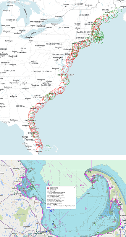
During March and April of 2024 a pilot project was conducted in Cape Cod Bay to send targeted messages to vessels out of compliance with the speed rules.
60 |
day test during Spring 2024 in Cape Cod Bay |
2 |
AIS transceivers monitor traffic and message vessels exceeding 10 knots |
10nm |
Majority of vessels slowed to compliance |
Leading the way with AIS
AIS
Capabilities
MotionInfo's Automated Identification System (AIS) network offers a comprehensive data solution for facilities management across various domains, including land, sea, and air.
MotionInfo provides real-time and historic tracking and data insights that are essential for the efficient operation across industries:
- Aeronautical
- Maritime
- Utilities and Telecomm
- Governmental
- Environmental and NGOs

MOTIONINFO
Coverage
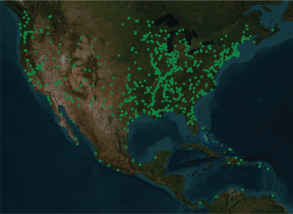
Leveraging comprehensive coverage of the Northeastern Hemisphere, the system enables our clients to monitor and manage the movement of vessels, aircraft, and land vehicles.
Applications
The real-time and historic data from MotionInfo' AIS network ensures seamless coordination, regulatory monitoring and compliance, enhanced safety, billable activities, and optimized resource allocation across all demographics effected by the movement of transport vehicles.
COMMUNICATION
Marine Notifications
AIS enhances maritime safety by providing real-time data on vessel identity, position, speed, and navigational status. This information is automatically shared with shore stations, other vessels, and aircraft.
-
AIS Safety-Related Messages: Transmit urgent safety and navigational information directly to vessels and authorities.
-
AIS Virtual Markers: Electronically indicate hazards or important locations on navigational systems.
-
AIS Geographic Notices: Provide real-time updates on specific navigational rules or restrictions for defined areas.
Growing the world's largest network
EQUIPMENT
Send & Receive
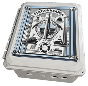
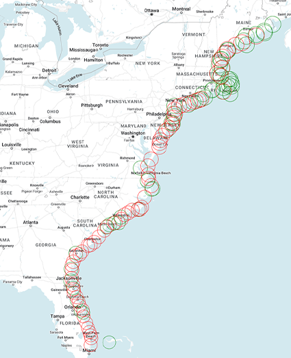
MotionInfo is upgrading and expanding it's network of Send/Receive stations to facilitate communication with vessels within their transmission radius.
Green circles are existing locations while red circles are proposed and underdevelopment stations

EQUIPMENT
Receive-only
Receive-only units are deployed to provide coverage of busy nautical and aviation lanes throughout the Northeastern Hemisphere and gather data on every AIS equipped vessel and ADS-B equipped aircraft within range.

DEPLOYMENT
Location
MotionInfo evaluates the potential of every location to ensure maximum coverage with minimal interference and simplicity of installation and maintenance.
Hosting
MotionInfo partners with many facilities and organizations who provide optimal placement of equipment while ensuring reliable power and connectivity. Special consideration and access is provided to our partners--click here if you would like to be considered as a host.
Quality Assurance
During deployment and throughout its life-cycle, extensive testing and monitoring takes place remotely on each station.
DATA
Real-time
Our system collects and delivers real-time data on every vessel within its network range, including details such as position, speed, and navigational status facilitating instant and automatic notifications to vessels.
Historic
Historic AIS data provides essential insights for safety, efficiency, and legal processes.
- Regulatory Compliance
-
Incident Reconstruction
- Liability Assessment
- Fleet & Area Analysis
- Weather Correlation
